Thursday 27 June 2013

Day 37 Fort Custer Rec Area near Battle Creek, MI to Wheatly, Ontario

June 25 

Fort Custer Rec Area to Wheatley, ON  Yay Canada!!

Thunder storm last night that wasn’t suppose to get us, did!!  Still raining lightly this morning.  Travelled through the city of Battle Creek, pop over 50,000.  Battle Creek is famous for two things and one is still popular today, a breakfast food.  Do you know what that might be?? 


We followed I94 East to Detroit. This area along the interstate has gently rolling sparsely wooded farmlands.  Farms are producing fruit, huge strawberry fields and vegetables.  This area is also known for the production of crude oil, various tools and automobile parts.  We did pass by a large Ford plant.  I was worried about going through such a huge metropolitan area but no worries!  Before we knew it we were watching for the signs to take us back into Canada!
 
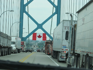
We chose to come across on the Ambassador Bridge from Detroit to Windsor, ON instead of the tunnel crossing the Detroit River.  There is a toll to pay before leaving Detroit; with the RV we paid $9.50 US; for just a vehicle it is $4.00 US.  The Ambassador Bridge is very impressive with a massive American Flag as you start to drive over it and a massive Canadian Flag on the other side.  All the semis were on the right lane and there seemed to be hundreds. 
 
 
Going through customs back into Canada was a piece of cake.  We pull up to the drive through and all the Customs Agent asks us is “How long we were in the USA, Where we were going and came from, and did we have any alcohol or fire arms.”  OK to go!!  Back on Canadian soil in Windsor, Ontario looking for an info centre.  Of course, more road construction and the info centre is closed!!  We head to Leamington/Wheatley which is close to Point Pelee National Park.  Stop in Leamington for groceries and beer!  There is a Heinz Factory here.  Who knew?  Leamington is known as tomato capital and its info centre is in the shape of a tomato.

There are “June bugs”, or “Fish Flies” or “May Flies” (whatever you want to call them) all over the place.  Stuck to cars, buildings, dead in piles around buildings, landing everywhere.  Millions of them maybe billions.  Good thing they don’t bite!!! 
 
Back at the campsite we can hear the thunder in the distance.  It’s coming, rolling in!!  Sunny and hot when we arrive and set up on Lake Erie.  The rest of the evening is thunder, lightning and then a downpour!!! 

Daily Stats: 
Today's distance: 339 km 
Weather:  Rain to Sunshine to Thunderstorms with intermittent down pours after 6 pm;
   High: 29 degrees; Lo: 20 degrees
Diesel Price: $4.05 gallon credit & $3.99 for cash; Reg gas $3.599
Wildlife:  Turkey vultures, deer, prairie falcon, millions of May flies
Campsite:  Holiday Harbour Resort on Lake Erie 
Today's news event:    Severe thunder storms coming across from Ohio


Battle Creek:  1894 two brothers named Kellogg experimenting developed a flake!!  Hence Kellogg Co., the Post Div of Kraft General Foods Corp and the Ralston Purina Co., which made Battle Creek the breakfast food centre.


Wednesday 26 June 2013

Day 36 Chicago, IL to Battle Creek, MI

June 24

Chicago, IL to Fort Custer Rec Area near Battle Creek, MI

Travel day, time to make some distance.  Thought I saw a Cardinal yesterday in the campsite, a red/orange bird.  This morning we did see him beating up a side mirror on a minivan.  I guess he didn’t like what he saw. 

We were glad we didn’t have to get onto I90.  From our campsite we were able to get onto Highway 47 by going under the interstate!  Whew!!  About 40 miles to connect with I80 below Chicago then head east.  This highway was very easy going country road with very little traffic until we got near Yorkville.  By avoiding the I90 we also missed a few tolls.  We only had one more toll on I80 leaving Illinois heading into Indiana.  The semi traffic here is nuts compared to Vancouver. 

Country scenery, still raining

Crossing into Michigan from Indiana, we are now on Eastern Time.  Had lunch at the Welcome Centre, back in the sunshine.  A lot of these highways are concrete so it feels and sounds like you are going over train tracks.  Did you know that “Springs bubbling up in a riverbed” are said to have been the inspiration for Kalamazoo’s catchy name, a Native American word that means “place where the water boils”. (No more, I think Embridge leak in 2010 fixed that)
 
We stopped in Fort Custer Recreation Area near Augusta.  Augusta is known for the Barn Theatre, the oldest professional resident summer theatre in Michigan which presents Broadway plays and musicals.  Nice campsite, lakes for fishing and hiking trails.  We found a turtle in one campsite so we turned him around to head back into the grass area.  We can hear the thunder in the back ground!!


Daily Stats: 
Today's distance: 408 km 
Weather:  Rain to drizzle to Sunshine; High: 29 degrees; Lo: 20 degrees
Diesel Price:  Near Gary, Indiana $3.59 gallon
Wildlife:  Red Crossbill bird in Chicago KOA, Turtle
Campsite:  Fort Custer Recreation Area
Walking:  5 km
Today's news event:  Severe Thunderstorm warnings in Ohio and Illinois coming our way  
Sports Event:  Chicago beat Boston in Boston Game 6, Chicago Stanley Cup Winners

Local News:  Protestor arrested near Kalamazoo due to Embridge!!
Michigan Stats:
Nickname:  Wolverine State
Flower:  Apple Blossom
Bird:  Robin

Day 35 Visiting Chicago, Illinois

June 23

Visiting Chicago Day II

Today we are visiting The Museum Campus; the Field Museum of Natural History, Shedd Aquarium, and Adler Planetarium.  Amazing sidewalks and cycle paths around here and surrounded by Lake Michigan.  We spent 2 hours at the planetarium next stop was the aquarium but the line up was a mile long to get in so we went to get lunch instead.  Pizza on the Campus.  Nothing special, we should have looked for a better restaurant.  It was getting hot, hot now. 
 Adler Planetarium
 View from Planetarium
Line up past the stairs waiting to get in!!
We walked back to Grant Park to Buckingham Fountain.  Beautiful, over looking Lake Michigan and gardens surrounding it.  
Buckingham Fountain 

It was just too hot to walk around anymore so we decided to head back to the campsite.  The traffic heading out of the city was just nuts.  We assumed an accident had happened but didn’t see anything.  By the time we made it back those thunder clouds were starting to appear.  Rain!!  It’s not suppose to rain on us during the day!!  It rained and thundered during the night but no wind like in Minnesota.  Well we are outta here in the morning heading to Michigan.


Daily Stats: 
Today's distance: 189 km 
Weather:  Sunshine with rain and thunderstorm by 6 pm; High: 31 degrees; Lo: 21 degrees
Diesel Price:  $4.01 gallon credit & $3.95 cash; and Gas Regular $3.59 gallon
Wildlife:  Nothing
Campsite:  Chicago Northwest KOA
Walking:  10 km around The Museum Campus and to Buckingham Fountain

Today's news event:  Medicine Hat flooding

Day 34 Visiting Chicago, IL

June 22

Visiting Chicago, IL 

Our campsite is about an hour from downtown Chicago.   All of the way in, road construction on the interstate and twice we had to go through toll booths at $1.50 each.  But once arrived, took a wrong turn and almost got lost but we made it thanks to Garmin and the transit map we had.  On the way to the pier, walking, the wind picked up and was blowing between the buildings, misting.  After arriving at the pier and looking back at the city, a mist was taking over the buildings.  Grey line bus tours leaving from here, trolley tours as well as a free trolley tour. Busy! Ships tied along the pier ready to go on harbour tours, dinner tours, weddings (which we must have seen at least 7), tall ship and a large jet boat all loading up with passengers.  The pier is long and has shopping, food, and entertainment!


Chicago’s skyscrapers are amazing.  The architecture, the height, and the detail on the buildings!  It’s too bad the fire of 1871 destroyed a huge portion of the downtown old wooden buildings.  We decided against paying $45 per person on the guided trolley and just walked from the pier to the John Hancock Observatory.  Up to the 94th floor, to see an amazing view of the city sky line.  You can see across Lake Michigan plus four states on a clear day.  The mist had blown away and we had a great 360 degree view.

 
We followed the trolley route and walked to the Magnificent Mile, shopping Tiffany’s; Rolex; you know the stores with guards in them!  Walking over the Michigan Avenue Bridge into the Block Thirty Seven shopping area, there were Zombies walking along heading in our direction.  I think there were over a hundred.  They attracted a following walking all through the shopping district to a square for a gathering and then later we saw them at Millenium Park.  
 Michigan Ave Bridge
 Zombie gathering

Walking back toward the lake is Grant Park and Millenium Park which features Cloud Gate (The Bean).  Pritzker Pavilion has free concerts and they were getting ready to set one up and giving away free popcorn.  By this time we had been walking around since 11 am and now it was 5 pm.  Time to walk back to the truck and find our way out of the city back to our campsite.

Bean - we are in the centre back

After dinner we walked to the pub next door to watch the 3rd period of the Chicago – Boston game 5.  A wedding was going on next door and a few of them were watching the third period with us.  Chicago won 3 – 0  Full moon tonight, right above the campsite! 

Stats: 
Today's distance: 140 miles return to KOA 
Weather:  Sunshine with clouds; High: 25 degrees; Lo: 20 degrees
Campsite:  Chicago Northwest KOA
Walking:  approx 70 blocks around the downtown of Chicago
Today's news event:  Calgary Saddledome flooded
Sports Event:  Chicago beat Boston in Game 5; Series now 3 – 2 for Chicago

Illinois Stats:
Flower:  Violet
Bird:  Cardinal

Sunday 23 June 2013

Day 32 & 33 Yankton, SD to Albert Lea, MN to Chicago, IL

June 20

Yankton, SD to Albert Lea, MN

Sad to leave Yankton!  We could easily stay here another week.  On the way north to see the falls at Sioux Falls!  Rolling hills and planted fields of corn, oats and sunflower, miles of it is between the two cities about 2 hours apart.  Sioux Falls, we found Falls Park easily off the interstate.  The visitor information centre has a five storey tower which offers 360 degree view of the park.  The Sioux Falls Trolley arrived as we got down from the tower so we hopped on and got a ½ hour tour of the downtown area, FREE.  The park is the original site of the Queen Bee Mill built in 1878 so farmers could avoid the cost of shipping wheat and was a 7 storey building. 


The Sioux Falls Light & Power Company (now Falls Overlook Cafe) completed in 1908.  The millrace and dam originally constructed to provide power for the Queen Bee Mill in the 1880’s.  Today the millrace is a viewing platform.  The park also has permanent sculptures that were winners in previous years downtown city walks that the city purchased after they won.  A very nice park!  Today the park covers 123 acres and each second, an average of 7,400 gallons of water drop 100 feet.
 Light & Power Co in front & Queen Bee Mill in back, what's left!

 Sioux Falls is also home to John Morrell & Co, a massive pig slaughter house.  While we were there we saw 3 semis pull in full of pigs.  Poor pigs, being made into Bacon!!  The airport is just north of the city and two fighter jets flew over our heads when we arrived.  What a thunder!!  After heading out it wasn’t long and we were crossing into Minnesota. 

Info centre with tower
 
We found Minnesota very flat, farm country and without a lot of livestock.  Oh yea and it was stinky!!  But it was very, very windy coming up from the south (Iowa).  There were miles and miles of wind mill farms.  I can see why.  Stopped in Albert Lea KOA just off the I90 for the night; windy here but still 30 degrees.   


Daily Stats: 
Today’s distance: 444 km 
Weather:  Sunshine; High: 30 degrees; Lo: 20 degrees
Diesel Price:  $3.71 and gas $3.54
Wildlife:  A deer and lots of road kill
Campsite:  Albert Lea/Austin KOA
Walking:  5 km                   

Minnesota Stats:
Flower:  Pink & White Ladys Slipper
Bird:  Common Loon
Insect:  Honey Bees ( we noticed bee hives throughout South Dakota as well)


June 21

Albert Lea, MN to Chicago, IL

Hello Summer!! What a night!!  Thunderstorm hit with pounding rain and wind.  The wind was so strong it was rocking the RV.  I was just glad we didn’t get hit with hail.  Not too far south in Iowa they had hail with their thunderstorm.  A few trees lost branches in the campsite but no damage to RV’s.  In Austin we were going to stop and visit the SPAM museum.  In 1887, George Hormel opened a small butcher shop.  Today Hormel Foods Corp is one of the largest food producers in the world.  Austin is also known as SPAM Town.  It was still raining so we carried on. 


More wind mill farms along the highway for miles.  Still windy but clearing up.  Looking south we could see the occasional lightning.  We drove past Rochester, MN known for the Mayo Clinic.  More rolling hills and farmland.  Then the landscape changed as we got close to the Wisconsin border and the Mississippi River with limestone bluffs.  Stopped for lunch at the Welcome to Wisconsin rest area. 
 Mississippi River
 
We drove around Madison which is the state capital of Wisconsin.  The city is split by an isthmus between two lakes.  It would have been nice to stay here but we wanted to get to Chicago.  Madison to Chicago’s outskirts is about 120 miles.  Nearing Chicago there was lots of road construction.  Plus we had to go thru tolls and pay. 


Daily Stats: 
Today's distance: 559 km 
Weather:  Thunderstorm – Winds, rain then Sunshine; High: 22 degrees; Lo: 18 degrees
Diesel Price:  $3.85 @ exit 267 Truck Stop Nodine, MN
Wildlife:  Hawk, Red Wing Blackbirds, Cranes??
Campsite:  Chicago Northwest KOA
News:  Mark got discharged from hospital

Wisconsin Stats:  Known as Badger State
Flower:  Wood Violet
Bird:  Robin

Day 31 Yankton, SD

June 19

Yankton Tour Day

I’m so glad we came to Yankton.  The campsite is wonderful and the weather couldn’t be better.  We drove into town and walked over the historic Meridian Bridge which was originally built in 1924 as a bi-level bridge for vehicle traffic on the upper deck and rail traffic on the lower deck with a vertical lift for boat traffic.  The lower deck wasn’t used and the bridge was decommissioned in 1984.  This bridge had an international connection linking Winnipeg to Mexico City via Hwy 81.  We walked across the upper deck .6 miles into Nebraska and then back again on the lower deck .3 miles into South Dakota. 
Meridian Bridge


Yankton has a 35 mile trail system along the river and through town.  We walked a few of them along the river front, into old downtown to view sculptures and checked out a replica building of the state capital as Yankton was the designated capital of the Dakota Territory in 1861.  It is the town where Jack McCall was hung in 1877 due to murdering Bill Hickok in Deadwood in 1876.  We visited the marker where Jack McCall was hung. 
  Meridian Bridge in back ground 

In 1957 the Gavins Point Dam was completed on the Missouri River thereby creating the Yankton Lake.  We drove across on a narrow piece of land into Nebraska over the dam.  Just up the road is the Lewis & Clark Visitor Centre in Crofton, Nebraska.  From their parking lot is a good view of the dam.
Crofton, Nebraska

Gavins Point Powerplant, Missouri River and Yankton Lake

The third time we drove into Nebraska was on the Discovery Bridge crossing the Missouri River on Hwy 81 and went to the Corps of Discovery Welcome Centre which has a very scenic overlook of the Missouri River valley.  We visited the Gavins Point Fish Hatchery and Aquarium.  It wasn’t very big but the displays they did have were very interesting.


Discovery Bridge
 
In the evening Ross and I got on the bikes and rode from one end of the campsite to the other.  It took an hour which included taking pictures of about 50 vultures soaring on the up draft off the river.  Also got a shot of a red headed wood pecker and the western meadow lark near the water.

 
Sapsucker on bicycle sign

Daily Stats:
Today's distance: 21km 
Weather:  Sunshine; High: 32 degrees; Lo: 20 degrees
Diesel Price:
Wildlife:  50+ Black Vultures, Red Breasted Sapsucker
Campsite:  Lewis & Clark State Park
Walking:  10 km & bike riding around the campsite
Today's news event: Mark back in hospital since Monday

Saturday 22 June 2013

Day 30 Belvidere, SD to Yankton, SD

June 18  

Belvidere, SD to Yankton, SD 

Thank goodness that storm passed us by last night.  This morning, sunshine and warm already.  1880 Town is an enclosed tourist attraction which was just down the road from our campsite, we just drove by and took whatever pictures we could. Scenery isn’t as great along the interstate but some businesses sure come up with some innovative bill boards to attract attention.  This stretch of highway is mostly ranch land and rolling hills.  The wildlife viewing is way down except for road kill and the skunk or two on the side of the road we certainly noticed!  The truck stop in Chamberlain was quite informative about the adventures of Lewis & Clark in this part of the state.  It had a replica of a keel boat that Lewis & Clark used on the Missouri River on the upper level of the info centre that went out on a deck with a view of the Missouri River.


Missouri River where Lewis & Clark made camp
 
We took a secondary highway #50 to Yankton to get a better view of the local area.  Interesting little communities!  We stayed in State Parks on our 2010 trip down the west coast and they were pretty nice.  Arriving in Yankton we stopped at the Lewis & Clark State Park and after checking in it was the perfect place to stay for a couple nights or a week.  Beautiful sites with electricity, trees, fire pits, birds and squirrels; 417 sites!  Lots of room between campers, not crowded in like sardines.  Bicycle paths throughout the park and all this for only $18 per night.


Across the Yankton Lake which is caused by the Missouri River being damed is Nebraska. 
 
Nebraska shores

 House of Mary Shrine 

Daily Stats: 
Today's distance: 392  km 
Weather:  Sunshine; High:  34 degrees; Lo: 20 degrees
Diesel Price:  $3.729 and gas $3.699
Wildlife:  Camel, deer, falcon, Ring necked pheasant, eagle
Campsite:  Lewis & Clark State Park
Walking:  5 km

Thursday 20 June 2013

Day 29 Custer City to Belvidere (I90 exit 170) 1880 Town

June 17

Custer City to Belvidere (I90 exit 170) 1880 Town

Just about 4 miles north of Custer City is Crazy Horse Monument which began on June 3, 1948.  It is not completed yet but will be the largest mountain carving in the world.  Crazy Horse’s head will stand 9 stories tall.  We didn’t want to pay $27 to see an uncompleted mountain carving so took our pictures from the hwy.

Crazy Horse Monument in progress
 
This part of the highway has a lot of very nice homes with the use of rock and brick.  There is a state campsite just north of Crazy Horse and it looks very nice.  We drove through Rapid City.  Lots of road construction in town which is always fun to get around pulling an RV.  But what we did notice that for a city of about 75,000 they have a lot of beautiful parks and recreation. Heading east on the I90 we noticed a lot of bill boards advertising “All Signs Lead to Wall Drug”.  A young pharmacist bought a store in 1931 and in 1936 he was about to call it quits.  His wife came up with the idea to put a sign on the highway “Free Ice Water”. 
 
I'm riding a Jackelope


Leaving Wall you cross the interstate and start the Badlands Loop 65 miles; it is friendly to RV’s.  It is like the coulees in Medicine Hat but only on a grander scale.  You have to see them to appreciate them.  The colors range from brown to yellow to pink.  Hard to imagine what happened here millions of years ago.


Time to find a campsite!  We see a sign so we follow it into Kadoka.  The campsite is slightly gown over and the first one we came to was even worse!  Just a little farther down the highway was a KAO near the 1880 Town, tourist attraction.  Great little KOA to spend a night.  But we did watch the thunderstorm approach.  Luckily it skirted around us and we did see the lightning and heard the thunder. Ross & John in their evening stroll met a guy from Texas.  We were planning on heading to Sioux Falls but he suggested we go to Yankton instead.  That’s our next destination.


Daily Stats: 
Today's distance: 302 km 
Weather:  Sunshine; High:  25 degrees; Lo: 10 degrees
Diesel Price:
Wildlife:  Deer, Prairie Falcon, 3 Bighorn Sheep
Campsite:  Belvidere KOA (very nice, clean) $34 incl cable, WiFi
Walking:  not much